Real-time tracking to better understand livestock grazing behavior
By Jameson Brennan and Mitch Stephenson
Quantifying and understanding grazing livestock behavior and resource selection on extensive rangelands has been an important question for researchers and grazing practitioners for decades.
A Nebraska study conducted in the early 1940s evaluated livestock grazing behavior over several days during the summer grazing period (Brinegar and Keim 1942). Researchers followed cattle over a 24-hour period and recorded cattle location and behavior (resting, grazing, etc.) every 30 minutes.
Nighttime was a noted challenge, with researchers indicating that full moon nights were best for recording observations because it limited the need for car headlights. Though challenging to conduct, this study provided some of the first insights into the amount of time cattle spent grazing (11 to 12 hours per day) as well as grazing selection on different landscapes in the central Great Plains.
Other studies have used visual observations to evaluate differences in individual animal habitat use on the landscape, predict spatial patterns of livestock behavior within pastures and quantify the effects of distance to water and pasture size on cattle activity and forage utilization (Senft et al. 1983; Hart et al. 1993; Howery et al. 1996). These early studies were pivotal in understanding the influence water and landscape features on livestock behavior and pasture utilization, and helped shape management recommendations for livestock producers.
In the late 1990s, the use of visual observations for studying cattle behavior was replaced by GPS tracking systems. The development of GPS technology allowed researchers to continuously monitor livestock locations over longer time frames and greater frequencies across a range of environments.
GPS-tracking technologies provide increased opportunities for researchers to ask novel questions to better understand grazing behavior under diverse management scenarios. These devices store animal location (latitude/longitude) at defined intervals (e.g. 10 minutes) that are accessed and analyzed following deployment (Swain et al. 2011; Bailey et al. 2018).
One of the main benefits to using GPS data is the ability to continuously monitor cattle locations and pair these locations with landscape features mapped using computer software (Putfarken et al. 2008). For example, GPS technology has been used to study livestock grazing patterns within patch burned pastures (Augustine and Derner, 2014); influence of landscape topography on grazing patterns (Raynor et al. 2021); strategies to improve livestock distribution through placement of low moisture blocks and low-stress herding (Bailey et al., 2008; Stephenson et al. 2017); and the relation of forage quality to livestock distribution (Zengeya et al. 2013).
Other studies have utilized GPS tracking to better understand the relationship between individual cows within a herd (Stephenson et al. 2017a) and the influence of livestock genetics on grazing distribution relative to the distance cattle travel from water and average elevation climb (Bailey et al. 2015).
Though much knowledge has been gained through the use of GPS technology to study factors that drive livestock distribution on the landscape, adoption of these technologies has been limited primarily to researchers within university and government organizations. This is in large part due to the previously high cost (~$1,500) of commercially available livestock tracking devices which are often cost prohibitive for both researchers and producers alike.
Recent adoption of off the shelf GPS tracking devices has effectively been used to track range beef cattle at a substantially reduced costs, potentially increasing accessibility of this technology to livestock producers.
Lab/homemade GPS devices Relatively inexpensive, readily available GPS components can be purchased and retrofitted with larger batteries and homemade collars (Knight et al. 2018, Brennan et al. 2021; Sprinkle et al. 2021). For example, Knight et al. (2018) used a commercially available, all-in-one GPS receiver and data logger common for vehicle fleet tracking and retroactively fitted a larger battery to extend the life for GPS collection. Total cost for the final GPS collar (including collar strap, housing for GPS unit and battery, etc.) was approximately $200.
Karl and Sprinkle (2019) developed GPS-collars using open source GPS, data logging and battery components with a total cost of only $54.78. However, the authors indicated three limitations to their collar design were reliability of their design construction, poor battery life and more GPS fix misses than the GPS receivers used by Knight et al. (2018).
McGranahan et al. (2018) developed a similar low-cost GPS unit with open hardware components for approximately $125. These lab made devices can also include motion sensing technology such as 3-axis accelerometers that can help identify GPS locations associated with animal behaviors such as grazing, resting and walking to better understand livestock selection on the landscape (Augustine and Derner 2013; Brennan et al. 2021, Sprinkle et al. 2021).
The referenced articles above have detailed lists of components and costs to develop low-cost GPS-units; however, skills required to build these devices can vary from soldering on larger battery packs on electrical boards, to altering and uploading computer code to microprocessors. In addition, deploying GPS collars on free ranging livestock also poses practical challenges including the ruggedness of the collars, battery life and accuracy of the GPS receiver.
Researchers and producers utilizing GPS collars, can expect a proportion (5% to 15%) of those collars to 1) run out of battery sooner than expected, 2) break or fall off cattle, or 3) stop working because of exposure to elements. This failure of the technology has been observed in both commercially built and home-made options for GPS tracking and should be considered in determining the number of animals to collar with GPS units.
Applications of GPS technology for producers Livestock grazing distribution, stocking rate, class of livestock and timing of grazing, are some of the primary grazing management variables that can be directly influenced by a livestock producer (Valentine 2001).
Livestock grazing distribution refers to the uniform dispersion of grazing across a given landscape or management unit. Poor livestock grazing distribution can cause rangeland degradation in specific areas, even if stocking rates are appropriately set for the pasture (Bailey 2005). As a result, grazing distribution is one of biggest challenges on rangelands, with many livestock producers having areas of their pastures that are either under- or over- utilized.
Livestock grazing distribution is influenced by a number of abiotic and biotic factors on rangelands. Abiotic variables in the pasture include horizontal and vertical distance cattle need to travel from water, topography, slope position and elevation rise. Biotic variables include the quantity, quality, type and distribution of vegetation available for forage within the pasture. GPS-tracking of livestock has been used to evaluate how these variables influence grazing intensities across a landscape.
Raynor et al. (2021) utilized data from GPS-tracked cattle at seven research stations across the United States to evaluate the effect of topography on grazing use. These researchers found that topography alone could be used to predict grazing locations and that GPS-tracked cattle utilized lowlands 120% more intensively than associated uplands. Rugged topography, large distances to water and low stock densities contributed to poor grazing distribution in the study, whereas small, well-watered pastures grazed at higher stock densities exhibited more uniform grazing across a landscape.
In addition, breed of cattle and genetic traits can also influence grazing distribution on the landscape (Bailey et al. 2015), and livestock producers may consider utilizing heritage livestock breeds that best match their climate and rangeland (Allred et al. 2013; Nyamuryekung’e et al. 2020).
While livestock grazing distribution challenges are not new, GPS tracking of cattle grazing may become an important tool for monitoring grazing use across the landscape at production scales. Modeling livestock grazing patterns can help researchers and grazing practitioners better understand how differences in management strategies influence rangeland health, wildlife habitat or livestock production objectives.
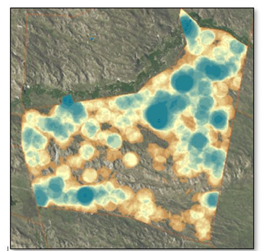
These data could be used to assist in developing grazing strategies or guiding grazing decisions. For example, visualization of cattle grazing intensity based on time spent grazing in specific areas of a pasture provides clear opportunities to improve pasture management by strategic placement of water and fence (either temporary or permanent) in areas that would improve grazing distribution (Fig. 1). More uniform utilization across a landscape reduces overgrazing at preferred areas and increases grazing use at locations that are only lightly grazed, thereby increasing harvest efficiency.
Figure 1. A point density map for a 1,500 acre pasture highlighting point densities of 10 GPS-track cows. BLUE represents areas of the pastures with high point densities, or areas with higher grazing intensity. BROWN and NO-COLOR represents areas with low point densities, or areas with minimal grazing intensity.
The information received from GPS tracking could also inform conservation management decisions such as identifying livestock use within environmentally sensitive areas, and give producers insight into differences in vegetation structure and composition to tailor grazing rotations based on production and conservation goals.
Water and fencing locations are one of the most effective tools for manipulating grazing distribution on the landscape. However, water and fence development are expensive and may not always increase output and therefore economic return on the investment (Dyer et al. 2021).
As highlighted above, GPS technology can help identify over- or under- utilized areas of pasture to inform decisions on cross-fencing or water development to:
The use of high-tinsel electric fence has allowed for more opportunities to divide pastures into smaller paddocks at a more reasonable cost; however, some areas are too remote, rough or lack adequate water to use these tools effectively. Other techniques to improve livestock grazing distribution include strategic supplementation placement to attract cattle to underutilized areas.
In a Montana study, cattle were attracted to upland areas away from water with the use of low-moisture block protein supplement (Bailey et al. 2001). In this study, grazing uniformity of upland areas was increased within 600 m of low-moisture block protein placements. A combination of low-moisture block and low-stress herding effectively increased grazing use at strategic locations away from water that typically received low grazing pressure during winter in the southwest USA (Stephenson et al. 2017).
This research indicated that as time spent near supplement locations increased, grazing utilization within surrounding areas also increased. If cattle did not consume supplement because of supplement unpalatability, novel supplements, or adequate nutrition in available growing forage during the spring, then supplements did not provide any added benefit to attracting cattle to lightly grazed areas in the pastures.
These studies highlight the applicability of using GPS technology to study supplementation and herding strategies on livestock distribution. One benefit of GPS-technology research is to better understand management strategies that can be implemented by producers without the need for tracking their own animals within a herd. This can be beneficial as the learning curve for processing and analyzing large geospatial datasets in meaningful ways can be steep and often requires specialized skills.
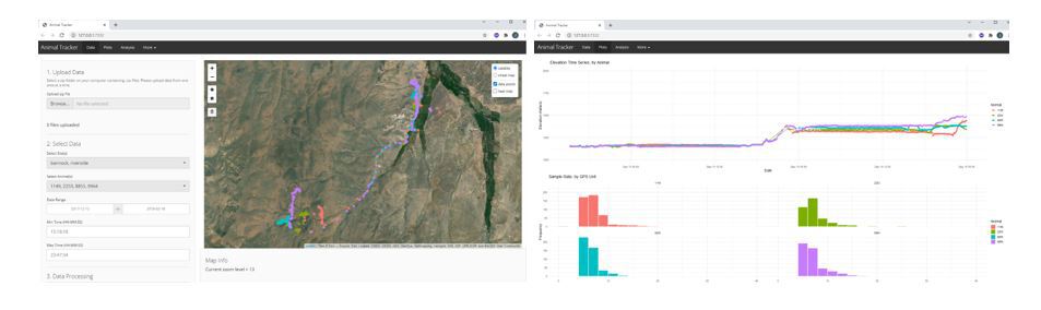
Advances in GPS data processing tools have been created to make data analysis more accessible to producers and researcher interested in collecting their own GPS data (Fig. 2) (Champion and Sukianto, 2020). In addition, as technological costs have come down for GPS tracking technology, many commercially available options are available for producers interested in tracking livestock. Often times these commercially available options provide data analysis platforms, mapping software and built in analytics to help users gain insights from their data on animal health, efficiency metrics and landscape use.
Figure 2. Screen shot of Animal Tracker web application developed by Oregon State University. The web application allows researchers and producers to upload, display, and create analyses of GPS data.
Exploring the benefits of commercially available products may be more applicable to livestock producers that want a more user friendly off the shelf option. In addition, by incorporating radio or satellite communication technology into GPS collars or ear tags, a greater number of commercial options offer the ability to monitor livestock locations in near-real time, greatly adding to the utility of GPS technology for making timely livestock management decisions.
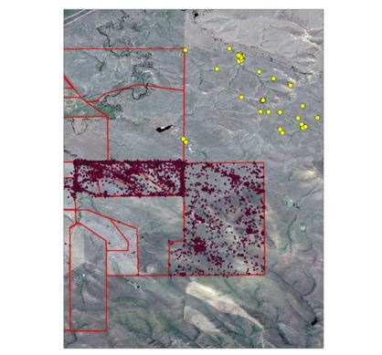
Real-time GPS data Numerous studies have demonstrated the utility of tracking livestock with GPS technology, but limited research exists using real time data capture on extensive rangelands. The possibility of having real-time GPS tracking opens up multiple options for application to livestock producers including immediate alerts for when animals are outside of pasture boundaries, or help locating animals in large pastures (Fig. 3). This may be especially valuable in remote locations where rough terrain or travel distance limits frequent opportunities for livestock managers to visually observe cattle welfare.
Knowing when cattle escape or are not within defined areas would also provide reassurance to managers that cattle are where they are supposed to be at any given time with alerts to phones or emails if cattle escape a pasture.
Figure 3. Real-time GPS tracking data for a yearling steer at the SDSU Cottonwood Research Station. Large yellow points in the upper right corner are locations where the steer escaped the property perimeter fence into the neighbors pasture. The animal was quickly located and returned to the property upon escape.
In addition, real-time tracking of animals may help identify sick individuals within a pasture or other issues of concern. For instance, tracking variability in movements associated with GPS-tracked cattle is an effective way to monitor livestock welfare such as water failure (Tobin et al. 2021) or disease detection with the added use of motion sensors (Tobin et al. 2020).
Having real time information on grazing behaviors could also assist livestock producers with decisions on when to move cattle to a new pasture.
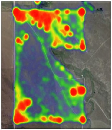
For example, real time heat maps of grazing locations within a pasture can be used to identify areas that are being overgrazed and may need to be fenced out using temporary fences (Fig. 4).
Figure 4. Real-time heat map of livestock use within a pasture. Red indicates areas of heavy use by the herd.
Additionally, the amount of time spent within riparian zones could be a metric for when cattle need to be moved or other management employed to reduce overgrazing on these sensitive rangeland areas.
Social association patterns, herd spread and distance traveled among cattle could also be used as metrics in determining when cattle are searching for more palatable forage as utilization increases at preferred locations (Tobin et al. 2021a).
In the future, this technology may provide options to grazing managers to monitor locations of the entire herd, track changes in individual or herd behavior, and identify key metrics to monitor health, welfare or grazing management remotely and with little added input.
Producer input According to the USDA National Agricultural Statistical Service (NASS), the number of farmworkers declined from 9.93 million in 1950 to 3.19 million in 2000, a 68% reduction (ERS, 2021, Accessed 10/10/2021). In addition, an estimated 82% of U.S. farm income comes from off-farm work (Bunge and Newman, 2018). This shift in the work force will continue to require creative solutions to accomplish agriculture objectives.
The advancement of technology may provide opportunities to efficiently improve range beef cow management while simultaneously reducing labor costs for the producer. This technological transformation has become commonplace in row cropping systems where the use of drones, precision seeders, yield monitors, and targeted applications have helped maximize yields and reduce inputs.
Consider the advancement of grazing management tools for many ranches in the Great Plains. The history of manipulating where cattle graze on a landscape has evolved from herding cattle to new grazing locations in expansive and open rangeland systems, to barbed-wire fence providing constraints on where cattle graze, to the less expensive electric fence that has changed our ability to employ more intensively managed grazing for specific animal and rangeland objectives.
In the future virtual fence technologies with GPS-tracking abilities may provide economically viable options to further limit cost and labor associated with managing cattle grazing dispersion (Anderson et al. 2014). The use of GPS-tracking to better understand and facilitate management is currently a real possibility.
Utilizing data derived from GPS-tracked cattle provides a resource that can assist with grazing management decisions, but these tools are best used with a thorough understanding of the rangeland and forage resources, livestock behavior, and other husbandry practices.
Though technology offers many opportunities to increase farm efficiency, it will not be able to replace producer experiential knowledge of their operation and herd. Many skills such as visual observations of rangeland utilization, health and body conditioning, and livestock handling will continue to require active management by trained practitioners.
Key to the success and adoption of these technologies for range beef cattle production is input and insight from livestock producers.
References can be found in The Range Beef Cow Symposium XXVII Proceedings.
Jameson Brennan is an assistant professor/research and Extension specialist in livestock Grazing with South Dakota State University, and Mitch Stephenson, is an associate professor with the University of Nebraska - Lincoln.